








Navigraph’s FSWeekend presentation opened with a story. CEO Magnus Axholt recalled how the company began 23 years ago when he and co-founder Stephen flew to Toulouse to knock on Airbus’s door, ran out of money, ended up lodging with a gardener 20 kilometres outside of town, and started building Navigraph Charts 1.0 in Visual Basic.NET at a kitchen table. It’s a good story, and it tells you something about the culture of a company that has been quietly building the infrastructure that most flight simmers rely on every day, without much fanfare.
That low-key approach continues in today’s presentation in Lelystad. No dramatic reveals, no teaser trailers. Just a methodical walkthrough of a year’s worth of work and three new features coming to Navigraph Charts shortly, with a live demo on an iPad on stage.
It might not make headlines the same way a new aircraft announcement does, but for anyone who uses SimBrief or Navigraph Charts regularly, there’s plenty here worth knowing about.
A year of updates worth noting
Before getting into what’s new, the team ran through what has shipped over the past year. SimBrief’s route calculator now supports SIGMET avoidance, allowing it to route around significant meteorological conditions rather than straight through them, which is a meaningful addition for anyone trying to replicate realistic dispatch decisions. European real-world routes from Eurocontrol have also been added, filling a gap that North American users haven’t had to think about for years.
On the charts side, VFR coverage has expanded significantly. Rogers Data VFR charts for Europe are now included in the unlimited subscription, alongside Jeppesen VFR charts covering approximately 2,000 European airports with airport diagrams, procedures, VFR reporting points, and waypoints. FAA helicopter sectionals for the US have also been added, covering low altitude routes, obstacles, terrain, and airspaces for helicopter flying around major metro areas.
Scratchpads, which were first teased at FSExpo 2025 and described as “coming soon after summer,” finally shipped a couple of weeks ago. The feature lets pilots jot down ATC clearances, ATIS information, performance data, and other notes directly within the Charts app, with smart stylus support for Apple Pencil users giving it something close to a paper-writing experience.

Three new features coming soon
The main announcement from today is three new additions to Navigraph Charts, demonstrated live on an iPad. All three are included in the existing unlimited subscription at no extra cost, and the team says they are arriving in the next release, not a future teaser.
The first is approach feathers, an overlay that appears automatically on your selected ILS or instrument-based approach, showing course, frequency, Morse identifier, and front or back course orientation at a glance. The visual shading on the feather immediately tells you whether you’re looking at a standard front course or a back course approach, and the feature also supports offset localizers, the kind used at airports like Bodø in northern Norway where terrain requires an angled approach path before going visual.
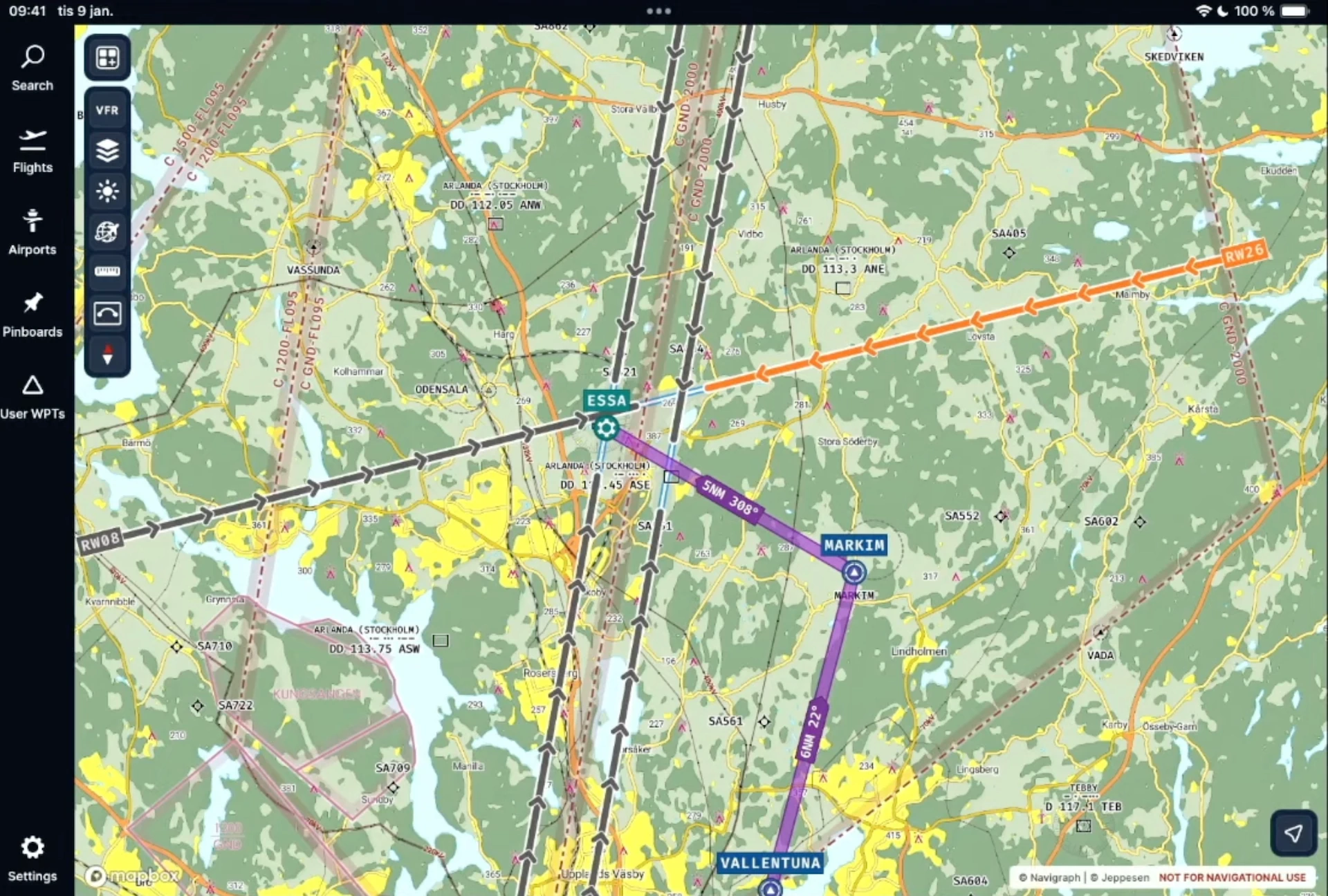
The second is extended runway centrelines, primarily aimed at VFR flying. Lines extend from each runway in the direction of approach, with length scaled to match the runway length itself, each segment representing one nautical mile. The demo showed Stockholm Arlanda with all runway directions displayed, making visual approaches and pattern flying considerably more intuitive at complex airports.
The third is a measurement tool, which has been a frequently requested feature. It allows users to place multiple nodes on the chart and measure distances and courses between them, with full multi-leg support. The team demonstrated measuring the taxi distance from an apron at Amsterdam Schiphol to holding point Victor 4 for runway 36L, which came out at just under two and a half nautical miles. The tool works on all platforms including touchscreen devices.

A fourth smaller addition was also slipped in: live ATIS source integration, showing the active ATIS report directly when a runway is flagged as not in use, giving more context for why a particular runway selection appears.
Navigraph Charts 8 is available across all platforms. The new features are coming in the next release, with no specific date given beyond “pretty soon.”